Rochebonne Castle
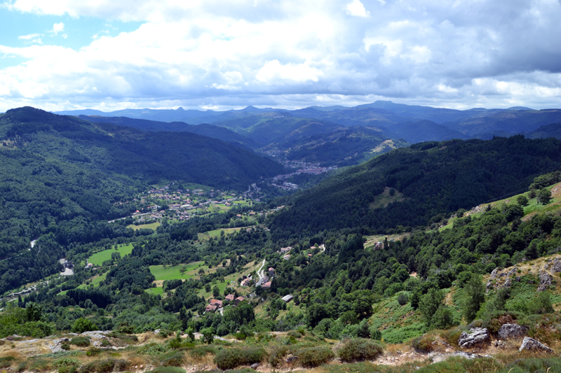
This beautiful walk will take you in the Eyrieux Valley highlands, from the river banks to the gorgeous ruins of the Rochebonne Castle, a veritable eagle nest perched at an altitude of 850 m, certainly one of the most beautiful jewels of the Hautes Boutières. Beside the castle, this walk offers a series of magnificent views on the Monts d'Ardèche, especially on the Sucs range. On its lower part, the walk along the Dolce Via is just as pleasant and far less tiring. Alternating undergrowth and meadows, river and castle, this walk will delight all, whether they like nature, landscapes or old buildings.
Description
- From the city hall square, cross the road D120, go down the rue de la Bascule, then, lower, the rue des Puces, that goes down steeply.
- Turn left in the direction of "Site de Rochebonne" and cross the bridge on the Eyrieux. After the plane trees line, turn right on the Dolce Via and, after 20 m, left to reach the château Lavis.
- Head past it and at the crossways with Impasse de la Mazat, take the track suitable for vehicles on the left for 250 m.
- At the end of the track, take the path on the right into the forest in the direction of "Château de Rochebonne, 6.2 km". After 50 m, take the wide bend and keep well on the main track, following the yellow markings without paying attention to the municipal markings. The cobblestone path climbs steadily up across nice woods.
- After 1 km, turn left and carry on up to the pasture that offers a beautiful view of the village.
- Continue on the path up to a narrow tarmacked road. Follow it for 900 m up to the road D478.
- At Tavaste, cross the road and take the direction of "Lautussac, 1.5 km - Saint-Jean-Roure, 4.9 km" and then the track going uphill.
- At Lautussac, follow the GR (long-distance path) up to the ruins of the Rochebonne Castle.
- You can walk around it and enter it by going down the path on your left. Afterwards, take back the GR and start going downhill.
- At Nant-Paillez, take the direction of "La Condamine, 0.9 km - Saint-Martin-de-Valamas, 3.3 km" and follow the GR going down to the old railroad (la Dolce Via).
- Once on the Dolce Via, at the Condamine crossways, turn right towards "Saint-Martin-de-Valamas, 2.4 km" After almost 2 km, skirt the impressive Pont de fer (Iron bridge) and continue on the path that will soon become a road on the verge of the housing estate of Saint-Martin-de-Valamas.
- At the Nant road crossways, turn left, still on the Dolce Via. You will pass underneath the Lavis Castle. Back to the bridge, cross it again and turn right in the rue des Puces. You are back in the village, on the city hall square, your starting point.
- Departure : In Saint-Martin-de-Valamas, go down the rue des Puces (Fleas Street), then turn left on the bridge accross the Eyrieux River
- Towns crossed : SAINT-MARTIN-DE-VALAMAS and SAINT-JEAN-ROURE
Forecast
Altimetric profile
Recommandations
: Pas de difficulté particulière si ce n’est le dénivelé important pour rejoindre le château.
Access and parking
From Le Cheylard or Saint-Agrève, take the road D120 up to the centre of Saint-Martin-de-Valamas.
Parking :
Report a problem or an error
If you have found an error on this page or if you have noticed any problems during your hike, please report them to us here: